Annexes
Annex 1: Glossary of RMMV Definitions
Show Glossary
Glossary of RMMV Definitions in German Financial Cooperation
360° Camera — A camera capturing images/video with a 360° field of view.
3G — Third-generation wireless mobile telecoms; up to ~2 MB/s (typical image 1–5 MB).
4G — Fourth-generation broadband cellular network; up to ~20 MB/s.
Ad-hoc surveys — Individual surveys on project outcomes/usage among beneficiaries/target groups; flexible but often lower data quality and relatively expensive.
Algorithm — A defined sequence of rules/steps for problem solving or computation.
Anonymous data — Data recorded to prevent linkage to the person who supplied it.
Satellite office — KfW sub‑country office or country office managed from a neighboring country.
Antivirus software — Software to prevent/detect/remove viruses/malware.
Application — Software performing coordinated tasks for users (desktop, mobile, or web).
API (Application Programming Interface) — Automated interface allowing software systems to exchange data with proper authorization.
Appraisal — KfW process verifying Feasibility Study results and defining project design with partner stakeholders.
ArcGIS — Commercial Geographic Information System (GIS) application.
Augmented reality — Computer‑generated 3D content overlaid on the real environment via device/smartphone.
BI (Business Intelligence) — Strategies/tech for data analysis and business information management (e.g., reporting, analytics, dashboards, mining, predictive/prescriptive analytics).
Big Data — Data sets too large/complex for traditional processing tools.
Building Information Modeling (BIM) — Collaborative, integrated planning/constructing of infrastructure projects in real time.
Bundesdatenschutzgesetz (BDSG) — German Federal Data Protection Act.
Cameras — Optical instruments for photos/videos (including 360°/VR); can be handheld, mounted, or on drones/satellites.
Catholic Relief Service (CRS) — International humanitarian agency of the U.S. Catholic community.
Cellular network — Mobile network using many limited‑power base stations covering “cells.”
CHIRPS / CHPclim — Quasi‑global rainfall datasets (see https://www.chc.ucsb.edu/data/chirps).
Cloud computing — Remote servers/services (compute, storage, databases, etc.) rented on demand (“the cloud”).
Collaboration tools — Software to optimize group processes (teamwork efficiency, reduced miscommunication, etc.).
CSV (Comma Separated Values) — Delimited text file format for tabular data.
Commercial use/license — Products/services offered for sale under proprietary licensing.
KCUS — Competence Centre for Environmental and Social Sustainability at KfW.
Community‑Based Participatory Research (CBPR) — Partnership research involving communities and researchers equitably.
Corrective Action Plan (CAP) — Follow‑up plan describing findings, corrective actions, responsible parties, and timelines.
Crowdsourcing — Collecting information/ideas/feedback from large, often anonymous groups using ICT.
Dashboard — UI presenting information via visualizations for quick comprehension.
Data — Facts/statistics collected for reference, management, or analysis.
Data analysis — Inspecting/transforming/modeling data to derive insights and support decisions.
Data breach — Intentional/unintentional release of private/confidential data to an untrusted environment.
Data encryption — Encoding data so only holders of the key/password can read it.
Data privacy — Preserving/protecting personal data from unauthorized access.
Data portal — Website aggregating and presenting data from multiple sources.
Data processing — Collection, storage, use, transmission, modification, alignment, restriction, erasure, or destruction of data (per GDPR Art. 4(2)).
Data security — Protecting digital data from destructive forces and unauthorized actions.
Data set — Related information elements (often tabular) handled as a unit.
Data sources — Proprietary, public, or open datasets; open data is publicly available (some restrict commercial use).
Data syncing — Keeping data consistent between stores over time (data synchronization).
Database — Structured information store enabling easy viewing/editing.
GIZ — Deutsche Gesellschaft für Internationale Zusammenarbeit GmbH (Germany’s main development agency).
Digital archive — Repository for long‑term access to digital information.
Digital Elevation Model (DEM) — 3D representation of terrain surface from elevation data.
Digital Impact Alliance (DIAL) — UN Foundation “think/do/replicate” tank on digital tech/data.
Digital recording — Capturing audio/video signals and converting to discrete digital form.
Document management tool — Software to track/manage/store large volumes of documents.
Drone/UAV — Pilotless aircraft; can carry sensors/cameras for monitoring (incl. IR, night vision, 3D).
Earth Observation (EO) — Gathering planetary information, often via satellite sensors (optical, IR, radar).
eLearning — Learning via electronic media/online.
eLearning tools — Tools/courses for digital learning (incl. RMMV/tech topics).
Encryption — Converting readable data to encoded form requiring a key to decode.
Energy Monitoring System (EMS) — Centralized DB for remote collection/analysis of energy production/consumption data.
Energy Performance Calculation (EPC) — Methods/software for building energy needs/audits/passports.
Environmental and Social Commitment Plan (ESCP) — Actions/measures to meet KfW ESHS requirements (attached to agreements).
Environmental and Social Impact Assessment (ESIA) — Study identifying E&S risks/impacts and mitigation (feeds ESMP).
Environmental and Social Management Framework (ESMF) — Principles/rules for projects with multiple yet‑unknown locations.
Environmental and Social Management Plan (ESMP) — Plan outlining E&S measures/responsibilities/timeline (often by phase).
E&S expert — Environmental and Social Expert supporting KfW PMs in risk assessment/monitoring.
e‑participation — ICT‑supported participation in government/citizen processes.
Ex‑post evaluations (EPE) — KfW evaluations ~3–5 years post‑completion to assess impact.
Facility‑owned usage information system — System to collect/manage usage info for PEA/facility operating infrastructure/services.
FAOSTAT — FAO database of food/agriculture data for 245+ countries/territories (since 1961).
Feedback loop — Mechanism to collect/react to user comments to improve systems.
Financial Cooperation (FC) — Part of Germany’s bilateral development cooperation; executed by KfW.
Financial Participatory Approach (FPA) — Mobilizing local populations via PRA, contests, awards, media, etc. (see FPA Manual/Sourcebook).
First‑person view (FPV) — Controlling a vehicle (e.g., UAV) from the pilot’s viewpoint.
Fixed wing — Aircraft generating lift via forward airspeed and wing shape.
For‑profit organization — Entity whose primary goal is profit.
Free Prior Informed Consent (FPIC) — Right of indigenous peoples to give/withhold consent to projects affecting them (per UNDRIP).
GIS (Geographic Information Systems) — Desktop or web tools to capture/store/analyze/present geospatial data.
GeoApp — KfW internal application for standardized project location data (FC Project Location Data Model).
Google Earth Pro / OSM / Bing maps — Common map/satellite sources for site screening.
Grievance redress mechanism (GRM) — Process for PAP/target groups to submit grievances/feedback to project actors.
IBAT / protectedplanet.net — Tools/databases for biodiversity/protected area screening.
Indigenous peoples (IP) — Culturally distinct groups descended from earliest inhabitants, maintaining language/culture; see World Bank ESS.
KC Theme/Sub‑Sector — Preselection column in KfW location template for quick location type lookup (not stored).
KML — Open XML standard for geodata (points/lines/polygons); WGS84 datum recommended.
mWater — Example mobile data collection software (used in Drought Resilience III, Ethiopia).
Mobile Data Collection (MDC) — Collecting qualitative/quantitative field info via mobile devices.
Mobile network population information system — Systems collecting/evaluating movement/behavior data of phone users.
Open data — Publicly available datasets, sometimes with commercial‑use restrictions.
OpenStreetMap (OSM) — Collaborative open map dataset.
Participatory methods — PRA/CBPR/PAR/FPA, micro‑narratives, participatory statistics, etc. for target‑group input.
PRA (Participatory Rural Appraisal) — Visual/interactive methods for community insights (e.g., maps, matrix weighting).
Project location data model — KfW FC standard for collecting/storing project location info (GeoApp).
Remote Management/Monitoring/Verification (RMMV) — Managing, monitoring, and verifying projects without full physical access.
Resettlement Action Plan (RAP) — Plan to mitigate displacement impacts.
Smart meters / Sensors / IoT — Devices measuring/transmitting data (energy, water, environment) often in near real time.
Smartphone meta‑data — Geotagging/time/bearing to support verification of photos/videos.
STATcompiler — DHS Program tool for custom tables across 90+ countries.
SWOT — Strengths, Weaknesses, Opportunities, Threats analysis.
Tableau/Power BI/BI tools — Analytics/visualization platforms (dashboarding, analysis).
TPM (Third‑Party Monitoring) — Independent monitoring/verification actor.
UN agency single audit principle — UN practice limiting full accounting audit by external parties.
UAV/drone regulation — Local rules on drone use (airspace, permissions).
VR photos/videos — Immersive media requiring compatible players/headsets.
WGS84 — World Geodetic System 1984 (coordinate reference system for KML/GeoApp).
Web application — Program served via web browser (e.g., Chrome/Firefox).
Webmapping — Visualizing/sharing maps online (interactive/dynamic).
Zoom levels/resolution — Map imagery resolution considerations (rural vs urban, update frequency).
Annex 2: Technical Tool Types and Data Sources Fact Sheets
Open Technical Tool Types & Data Sources
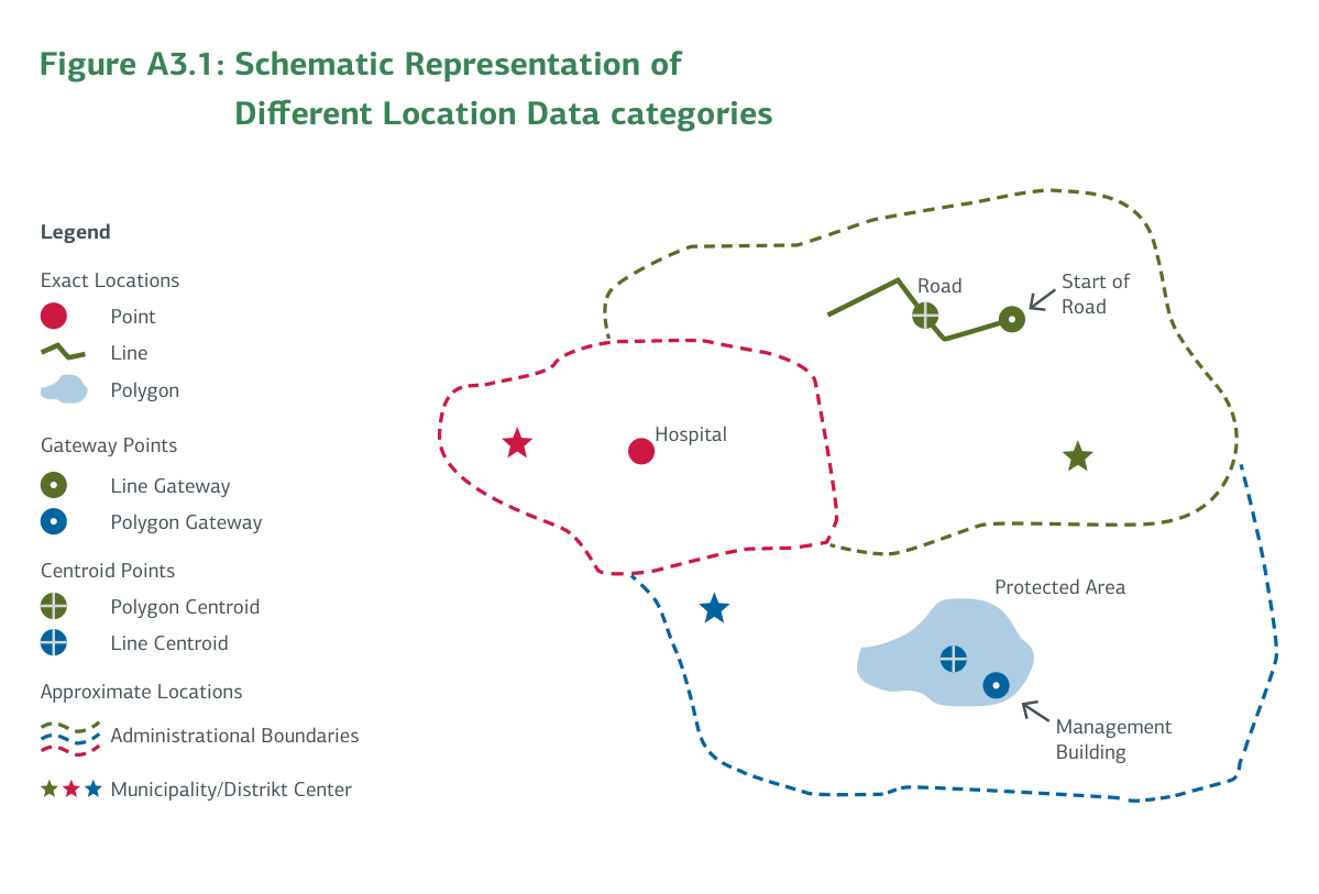
Annex 3: KfW's Project Location Data Collection and Management Approach
Open Project Location Data Model
Annex 4: List of RMMV Literature
Show Literature List
- Bott, M., G. Young, and B.-S. Gigler. 2012. “The Potential of Crowdsourcing for Better Governance in Fragile State Contexts.” In Closing the Feedback Loop: Can Technology Bridge the Accountability Gap? Ed. B.-S. Gigler and S. Bailur, 107–48. Washington, DC: World Bank. https://elibrary.worldbank.org/doi/abs/10.1596/978-1-4648-0191-4_ch5
- Cato, W., and K. Mobley. 1999. Computer-Managed Maintenance Systems: A Step-by-Step Guide to Effective Management of Maintenance, Labor, and Inventory. Houston: Gulf Publishing Company.
- Complete guide to GDPR compliance. https://gdpr.eu/
- Dette, R., J. Steets, and E. Sagmeister. 2016. “Technologies for Monitoring in Insecure Environments.” GPPi, Berlin. https://gppi.net/media/SAVE__2016__Toolkit_on_Technologies_for_Monitoring_in_Insecure_Environments.pdf
- Dipl.-Ing. Carsten Stammeier. 2015. “Consultancy Report on Solutions on Remote Project Monitoring in Volatile Environments.” Unpublished.
- DLA Piper. 2024. “Data Protection Laws of the World—Full Handbook.” https://www.dlapiperdataprotection.com/system/modules/za.co.heliosdesign.dla.lotw.data_protection/functions/handbook.pdf?country=all
- Egeland, J. 2011. “To Stay and Deliver: Good practice for humanitarians in complex security environments.” UNOCHA. https://www.unocha.org/sites/unocha/files/Stay_and_Deliver.pdf
- Flick, U. 2011. Triangulation. Eine Einführung. VS Verlag für Sozialwissenschaften: Wiesbaden.
- Global Unmanned Systems. 2015. “Use of Unmanned Aerial Vehicles (UAVs) in Impact Assessment.” IAIA, Florence. https://conferences.iaia.org/2015/Final-Papers/Use%20of%20UAVs%20in%20Impact%20Assessment.pdf
- GSMA. 2024. “The Mobile Gender Gap Report 2024.” https://www.gsma.com/solutions-and-impact/connectivity-for-good/mobile-for-development/blog/the-mobile-gender-gap-report-2024/
- HIF. 2017. “Community-based mapping, modelling and monitoring of endangered heritage.” https://www.elrha.org/wp-content/uploads/2017/10/fr-lsn-community-mapping-heritage-2017.pdf
- Institute of Development Studies. (n.d.) “Participatory Methods.” https://www.participatorymethods.org/
- KfW Development Bank. “Our Way of Working: Our project cycle.” https://www.kfw-entwicklungsbank.de/International-financing/KfW-Development-Bank/Tasks-and-goals/Unsere-Arbeitsweise/#
- KfW Digital Rights Check for Financial Cooperation. https://digitalrights-check.bmz-digital.global/kfw/
- Norman, B. 2012. “Monitoring and Accountability Practices for Projects Implemented Remotely in Insecure Environments.” Tearfund. https://www.alnap.org/help-library/monitoring-and-accountability-practices-for-remotely-managed-projects-implemented-in
- Sagmeister, E., J. Steets, A. Derzsi-Horváth, and C. Hennion. 2016. “The use of third-party monitoring in insecure contexts.” GPPi, Berlin. https://www.gppi.net/media/SAVE__2016__The_use_of_third-party_monitoring_in_insecure_contexts.pdf
- Gibson, M. 2021. “Implementation Monitoring.” Abdul Latif Jameel Poverty Action Lab. https://www.povertyactionlab.org/resource/implementation-monitoring
- Souness, C. 2011. “Monitoring & Beneficiary Accountability in Remote Managed Locations: An assessment of Tearfund’s monitoring & accountability practices Kandahar, Afghanistan.” https://www.elrha.org/wp-content/uploads/2015/01/baseline_assessment_of_kdh_monitoring_practices.pdf
- Statista. 2024. “Average selling price for smartphones worldwide in 2019-2029, by region (in U.S. dollars).” https://www.statista.com/forecasts/1286704/worldwide-smartphone-average-price
- Statista. 2024. “Percentage of mobile device website traffic worldwide from 2015 to 2023.” https://www.statista.com/statistics/277125/share-of-website-traffic-coming-from-mobile-devices/
- Statista. 2024. “Number of smartphone mobile network subscriptions worldwide from 2016 to 2023.” https://www.statista.com/statistics/330695/number-of-smartphone-users-worldwide/
- Stöhr, T. 2017. “Big Data. Anwendungsmöglichkeiten in der Entwicklungszusammenarbeit.” Institut für Weltwirtschaft Kiel.
- TrendLabs Primer. 2012. “5 Data Security Risks Every Small Business Should Know About.” https://documents.trendmicro.com/assets/primers/five-data-security-risks-smb-should-know.pdf
- UNOCHA. 2013. “Big data and humanitarianism: 5 things you need to know.” https://www.unocha.org/publications/report/world/five-things-you-need-know-big-data-and-humanitarianism
- UNDP. 2013. “Innovations in Monitoring & Evaluating Results.” https://www.undp.org/publications/discussion-paper-innovations-monitoring-evaluating-results
- UNDP. 2015. “Trust Fund Factsheet—Peacebuilding Fund, MPTF Office.” https://mptf.undp.org/factsheet/fund/PB000
- “State-of-Digital”-Reports – Global and per Country. https://datareportal.com/reports/
- World Economic Forum. 2016. “4 billion people still don’t have internet access. Here’s how to connect them.” https://www.weforum.org/agenda/2016/05/4-billion-people-still-don-t-have-internet-access-here-s-how-to-connect-them/